To Define a Spatial Extent for the Import Process
- Delete any previously imported features and toggle off the display of any referenced files.
- Place a rectangular fence on the map of Australia.
- In the Interoperability dialog, select the Import process node.
-
Select Fence for the Spatial Area.
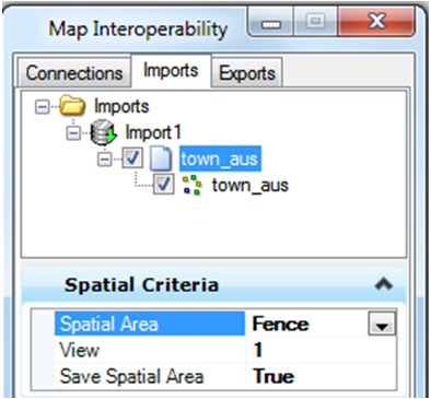
- Right-click on the feature node and select Import.
- Only those features within the fence will be imported.
-
Select the feature node, right-click and select Save.
This will save the import process with the fence coordinates posted.
-
Reference the saved Import process again.
The reference operation will only reference those features inside the saved fence area.
This is helpful if you have a very large file, perhaps a list of survey monuments. You can define an import process for a particular project. Set up the appropriate symbology and define the project area with a rectangular fence. You can then reference or import only the project area, making the process much faster and much simpler.